
Tracks
Tracks of Trelissick Park
There are only two named tracks shown on the current park maps - The Ngaio Gorge Track and the Northern Walkway.
And only one of these two tracks (Northern Walkway)
shows up consistently via sign posts at track junctions.
There are a variety of other named tracks and routes through the Park and some of these overlap each other.
Hence there are numerous ways to explore the Park, by walking or running, with family and friends, human and canine.
(There are also a few tracks without names.)
This page tries to explain some of this - a work in progress.
The Ngaio Gorge Track
The Northern Walkway
Te Araroa Trail
The Fish Ladder Track
The Sanctuary to Sea Walkway
Memorial Track for Frances Lee
Track to the memorial site for the 51 Mosque victims
Forest Remnant Track
Oban Track (Barry's Track)
Loop Track
other track options
other track signs
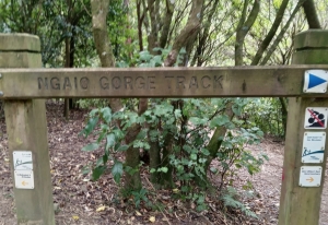
The Ngaio Gorge Track
The Ngaio Gorge Track
This is the backbone stream side track of the whole Park - shown on various maps, but not often directly signposted within the Park. The good news is that this is the most intuitive of the tracks. Just follow the two major streams where you can. This track has changed considerably over the decades, especially in the Korimako Stream valley as bridges were added or replaced.
(traveling downstream) Start at the Waikowhai Street entrance to the park, descend into the park to stream level and follow the Korimako Stream, past bridge 1, past Wightwick's Field, and then past bridges 2, 3, 4 and 5. Eventually, near the actual Ngaio Gorge the track starts to climb, initially through a rough section, and then connects to and follows a ridge track above the actual gorge, past the path to the Fish Ladder until you are nearly at the "Crossroads" track junction. At this point you start down again to stream level going past the "Lookout" - which looks upstream Kaiwharawhara into the lower Ngaio Gorge.
Upon reaching the Kaiwharawhara Stream you follow the track, keeping the stream on your right. There is one track section just before Bridge 6 which is very rough and not easy to navigate when the stream is high. The track then continues through the whole lower park, passing Bridge 6, then Bridge 7 and eventually past the Debris Trap and the remains of the Magazine buildings and the two historic stone walls. The track then leads to the exit from the park on the lower Ngaio Gorge Road.
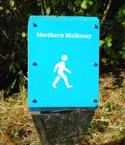
The Northern Walkway
The Northern Walkway
for the WCC description of the whole walkway, see: The Northern Walkway. This Wellington City walkway is very well sign posted and identified throughout its Trelissick Park stage. On this part of the walkway it traverses the park going from the Waikowhai Street entrance near Crofton Downs to the Hanover Street entrance in Wadestown.The Northern Walkway is identified by the prominent blue topped sign posts, before and after every track junction. The total walkway is 14.9km long and takes at least 4 hours to complete, but can be done in stages. The Trelissick Park stage is described below (traveling downstream).
Start at the Waikowhai Street entrance, descend into the park to stream level and follow the Korimako Stream, past bridge 1, past Wightwick's Field to the first path junction. At this junction turn left and head up the track until you are nearly at Trelissick Crescent. Following the blue topped sign posts you turn right and follow the track parallel to Trelissick Crescent. You pass the Frances Lee track and the next (un-named) track before turning right and starting downhill, passing a prominent power pylon, and a memorial bench and the Crossroads path junction until you reach bridge 6 across the Kaiwharawhara Stream. Cross the bridge and start the climb up to the Hanover Street entrance to the Park. At that point the Northern Walkway continues to the right, upward on Hanover Street.
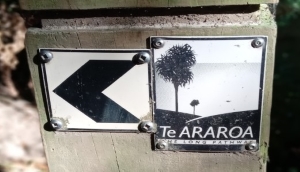
Te Araroa Trail
Te Araroa Trail
for the description of the complete New Zealand's Trail (The Long Path) see: Te Araroa Trail. This trail traverses Trelissick Park and is well sign posted with the small trail markers as shown in the picture. At all track junctions you may have to look carefully to make sure, but the marker will be there on one side of the junction post.(traveling downstream.) A short description is that this track coincides with the Ngaio Gorge Track throughout the Korimako Stream valley, all the way to bridge 6 in the Kaiwharawhara valley. At bridge 6 it joins the Northern Walkway crossing the bridge and climbing up to the Hanover Street entrance.
The longer description is to start at the Waikowhai Street entrance to the park, descend into the park to stream level and follow the Korimako Stream, past bridge 1, past Wightwick's Field, and then past bridges 2, 3, 4 and 5. Eventually, near the actual Ngaio Gorge the track starts to climb, initially through a rough section, and then connects to and follows a ridge track above the actual gorge, past the path to the Fish Ladder until you are nearly at the "Crossroads" track junction. At this point you start down again to stream level going past the "Lookout" - which looks upstream Kaiwharawhara into the lower Ngaio Gorge.
Upon reaching the Kaiwharawhara Stream you follow the track to bridge 6. There is one track section just before Bridge 6 which is very rough and not easy to navigate when the stream is high. From bridge 6 the Te Araroa Trail coincides with the Northern Walkway, so cross the bridge and start to climb up to the Hanover Street entrance to the Park. At that point Te Araroa Trail continues to the right, upward on Hanover Street.
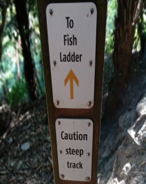
The Fish Ladder Track
The Fish Ladder Track
The path to the Fish Ladder.
This track is entirely missing from the map, but is obvious when walking along the ridge line track (on the Ngaio Gorge Track) above the actual Ngaio Gorge. The path down to the fish ladder view point is steep. It leads to the middle portion of the Ngaio Gorge where the Korimako and Kaiwharawhara join - with the Fish Ladder visible where the Kaiwharawhara exits from the tunnel under the rail line.
To save the effort of walking down to the stream level - and then back up again, here is what you would see:
photo of the Fish Ladder
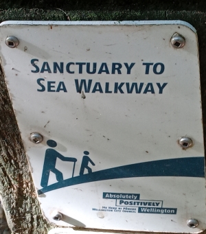
The Sanctuary to Sea Walkway
The Sanctuary to Sea Walkway
for the description of the complete Sanctuary to Sea Walkway, see this link: Sanctuary to Sea WalkwayThe description on the above link assumes starting at the Sea end of the Walkway. However
in keeping with the other track descriptions on this Trelissick Park Group website, we will go downstream.
Going downstream is also easier to describe, since this track overlaps and follows
the already described Ngaio Gorge Track.
Just follow the streams and keep an eye out for the Sanctuary to the Sea sign markers on posts along the way.
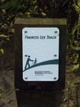
The Frances Lee Track
Frances Lee Track
This track connects from the Northern Walkway below Trelissick Crescent, down the slope to near Bridge #4 on the Korimako Stream.The track was named for Frances Lee in 2014. (Picture taken on Christmas Day 2014.)
Frances initiated the Trelissick Park Group for restoration of the park in 1991 and has been a strong motivating force in the Group over many subsequent years.
Cr Andy Foster suggested that a track in the park should be named after Frances Lee. The track leading off the Northern Walkway (below Trelissick Crescent) down to just upstream of bridge 4 was named ‘The Frances Lee Track', with a plaque at each end. It is a well used track with quick access to the Koromiko valley, through well-established and attractive bush. There is also historical interest, as the upper part appears to follow an old benched track.

The track to the memorial plantings for the 51 Mosque victims
The 51 Mosque shooting victims memorial plantings access track
There is a circular track providing access to the 51 memorial tree site -
circular in that the planting site can be approached from two directions.
Heading uphill from bridge 6 towards the Hanover Street entrance there is a
rough connection path just before a series of steep steps. This path stays
parallel to the stream and takes you to the 51 memorial tree site.
Coming downhill from the Hanover Street entrance, there is an unmarked track heading
down to the planting site.
Hopefully someday the two ends of the track can be better signposted and the track can be upgraded
from its current rough state.
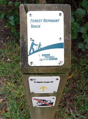
Forest Remnant Track
Forest Remnant Track
The Forest Remnant Track entry is at one end from the Crossroads as shown in the picture.
A small part of this track goes across private land, so please stay on the track. And the track is
generally in rough shape, so take care on your walk.
The track does go through some original groves of trees so is botanically interesting.
- It is a work in progress to adequately describe this track. It does show up with its name on
some older maps of the park, but not current ones except as a 'route' (without a name).
Starting from the Crossroads the track traverses much of the slopes up from the Kaiwharawhara Stream.
Initially below Trelissick Crescent but then below the Ngaio Gorge Road. At the mid point of the track, there
is access to the Minor Entrance on the Upper Ngaio Gorge Road. From there the track descends to the valley
floor - connecting with the stream side tracks. The track is narrow in places, as well as rough.
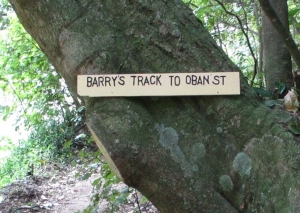
Oban Track (Barry's Track)
Oban Track (Barry's Track)
This is the newest track in Trelissick Park, connecting from the Oban
Street entrance (Entrance 7) in Wadestown down a steep set of steps and then a pathway to Bridge 7.
It was a several decade struggle to get the second entrance from the city side of the park officially
accepted by the City which required a new bridge across the Kaiwharawhara Stream before a new
entrance and official track would be built. Funds for the new
bridge came from a number of sources. The plaque on the bridge lists Frances Lee,
Wellington City Council, Transpower, Tararua Tramping Club, (Michael Taylor Bequest) and Public Donations.
For years the track on the Oban slope existed as an informal path - mainly used to access various predator bait stations and traps
on that side of the park.
The track could appropriately be named "Barry's Track" for the person who developed and maintained the
track for many years and protected the public access from Oban Street - Barry Durrant.
The picture shows the sign which was initially there when the track opened - but was removed without permission.
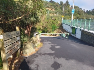
Trelissick Park Loop Track
Trelissick Park Loop Track
for one description of the Trelissick Park Loop Track see this link: Trelissick Park Loop TrackThe description on the above link assumes starting at the lower end of the park and
doing a two hour loop walk. This walk uses several other tracks, already described on this page.
But it is referenced as a separate loop walk option on several websites, so is included here.
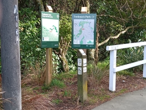
The loop track is also shown on the official WCC map signs at park entrances.
The start point of this loop track (at Entrance 6) is shown in the picture. And the above link to the description
of the track has a map of this loop track.
Other Tracks
Other track options
There are a few other tracks - mostly small connecting tracks, but one major track without an agreed name.
> Hanover track - the track from bridge 6 to the Hanover Street entrance is commonly referred to as the Hanover Street Track or just the Hanover Track.
> Debris Trap access - this is a wider vehicle access track - from entrance 5 on the Ngaio Gorge Road down to the Debris Trap.
> Forest Remnant access track - the Minor Park entrance near the top of Ngaio Gorge Road provides a short access track to connect to
the middle of the Forest Remnant Track. The picture to the right shows the start of this access track.
> 'Honeysuckle' track - so named by a couple of intrepid volunteers who spent many days over several years clearing out large
infestations of honeysuckle. This track connects from the Northern Walkway (near entrance 4 on Trelissick Crescent)
to the ridge track above the actual Ngaio Gorge. This is the one major track without an agreed name.
- these 'other tracks' is a work in progress to describe these various bits and pieces of existing tracks.
The picture is of the minor entrance access on Ngaio Gorge Road to the middle of the Forest Remnant Track.
Other Signs
Other signs
There are many other sign variations. Sometimes they are obvious in intention and sometimes they are helpful.
Here is one helpful one at stream level in the Kaiwharawhara indicating the start of the Forest Remnant
Track - heading up to the Ngaio Gorge Road.

Trelissick Park Group
Page last updated: 5 July 2024