
Park History
Tracks and Transport
The Kaiwharawhara Pa, at the mouth of the Kaiwharawhara Stream was inhabited before and during early settlement days by a tribe of Ngati-tama who migrated through the Manawatu from Taranaki to eventually settle in the Kaiwharawhara area. Ngaio Gorge formed a natural access way between Wellington and the Coast, and was much used by the Maori on route north through the Te Wharou Range to Wanganui and Taranaki. The Trelissick Track, which generally follows the alignment of the Northern Walkway through Ngaio Gorge, was likely to have been used by the Maori and certainly by early settlers and residents of the areas. Ngaio Gorge was also used as a source of food and for hunting by the Maori. The tribal chief during the earliest settlement days was Taringa Kuri, or Dog's Ear who was hostile to the settlers and to the sale of Maori land. However, in 1839, Taringa Kuri's resistance was overcome and he sold his land to Wakefield's New Zealand Company for clothing and other goods. The Kaiwharawhara Kainga was principally a Te Ati-Awa settlement although Taringa Kuri was a Ngati Tama Chief.
In 1841, Mein-Smith, the prominent New Zealand Company surveyor who laid out Wellington, improved the Maori track through the gorge to form a pedestrian way between Kaiwharawhara and Khandallah. This was followed in 1845 by the construction of a road up the gorge which was commissioned by Captain Daniel, whose "Trelissick Farm", named after his estate in Cornwall, was at the head of the gorge. This road became a popular by-pass for the early stages of the Old Porirua Road which was extremely steep. In 1846, the gorge access was again improved when Governor George Grey, with a militarists' appreciation of the old Roman Road idea, enlarged and upgraded the gorge road in order to send his troops to fight Te Rauparaha. Duncan Fraser who leased a 40-acre block for farming on the Hanover Street spur was another early settler.
By 1860, the Cobb & Company coaches were using the Gorge route to make their passages north. In September 1898, the Onslow Borough Council approved a plan for a new road to be surveyed and constructed. This road followed much the same path as the present Ngaio Gorge Road. The Wellington- Manawatu Railway Company established a rail link though the gorge in 1874.
The Trelissick Track between Hanover Street in Wadestown and Trelissick Crescent in Ngaio was a walking link since the late nineteenth century.
Land
The area was named in the early 1840s, when Captain Daniell built his home and established the family at “Trelissick”, their name for their 100 acre country property.
By 1900 Trelissick Bush was also called Major Deane’s Bush as the local residents knew of the ownership and the intent to open the land for private sale. The Wellington Tree Planting and Scenery Preservation Society established in 1895 lobbied for the Scenery Preservation Bill to proceed in parliament, they wished to acquire the land believing that future generations would bless them for their foresight.... In February 1921 their hard work paid off and the joint purchase between the Government and Wellington City Council created the new Ngaio Gorge Reserve. Described in The Evening Post, 28/2/1921: ‘A new strip of bush-clad land along the Manawatu Railway, following the Ngaio Gorge almost to Ngaio... has recently been purchased from the Trelissick Estate, to be a public reserve.’
The gravel heaps galvanised NPA into action and the Trelissick Park Group was formed in June 1991 with the initial name being the "Trelissick Park/Ngaio Gorge Working Group”.
Between 1920-22 11 hectares were acquired for the Park. Subsequent parcels were added, to bring the total to just over 18 hectares by 1995. More recently, two parcels were purchased – an area off Ngaio Gorge Road where the historic powder magazine building is situated and another off Waikowhai Street, Ngaio. Both have provided excellent east and north entrances to the Park. The large, flat area of Wightwick’s Field was generously donated by the Wightwick family to the WCC and another piece of land below Oban Street, Highland Park, was added to the Park when a WCC property was sold. Chris Horne has provided some of the history of the Oban Street extension to the park which now has a new entrance and track. For this history from the mid 1990s see Historic Oban Street information.
The total area for the Park is now 24 hectares, including the three areas of leased land described below (compared with 100 hectares in Otari/Wilton Bush).
Parts of the Park adjoin Railways Corporation land below the Johnsonville railway and parts border private land. Some owners off Hanover Street have covenanted their hilly slopes down to the stream to the QEII Trust, so the land will remain in bush in perpetuity.
There are small areas of road reserve along Ngaio Gorge Road and a larger area from the lower Park entrance from Kaiwharawhara Road towards the magazine.
Two areas next to the Korimako Stream (between bridges 2 and 3, and bridges 4 and 5) have been leased to WCC by KiwiRail under Licence to Occupy No. 61023 of 28 February 2005. The total area is about 1 hectare.
The area bounded by about 20m below the railway line and Kaiwarawhara Stream from Hanover Street up to the confluence of the Kaiwharawhara and Korimako Streams is also leased to WCC from KiwiRail under Beautification Lease No.50376 of 30 April 1982. The area is 2.75 hectares.
Other History
Early reports from the Onslow Historical Society record the park being used for picnics and swimming.
Two historic dry-stone walls border the track from the lower Park entrance, Two stone buildings to store gun-powder were built in 1879-1889 in the lower Kaiwharawhara valley as a more isolated alternative to the busy streets by the Mt Cook magazine. Ammunition was carried from the Waterloo Hotel's jetty at the Kaiwharawhara Stream mouth from June 1880. There were problems with destructive flooding, slips and roof damage. The army offered the magazine buildings for lease in 1921. The property was sold in the 1940s. Subsequently the area was used for industrial activity, including a plastics factory and a panel beater. The area was purchased by Wellington City Council in 1994 and the factory was demolished. In 2000, the magazine roofing was destroyed in a fire when a security van was set alight after a robbery. The stone walls of the magazine were then preserved as ruins.
NZ Defence fortifications including Kaiwharawhara Gunpowder Magazines.
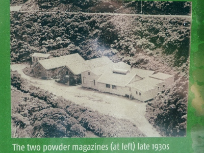
Gunpowder Magazines in the 1930s.
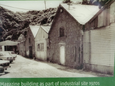
Gunpowder Magazines in the 1970s.

Trelissick Park Group
Page last updated: 6 June 2021